
Following the Shrewton Trail
a delightful walk in this Wiltshire village

It’s still only April, and England is in a heatwave. It’s almost unbelievable.
I had better make full use of this - it might snow next week!
Diary - Monday April 28th. — Go to Shrewton and walk the trail (a PDF file has been stored on my computer for over a year).1
No need for a coat or even a light jacket today. The temperature is quite warm and set to rise each day this week. With only wisps of white in the blue sky I drive to the Wiltshire village of Shrewton, a place I have driven through an uncountable amount of times. I think I may have stopped once to buy petrol at Bridge Garage many years ago and have, more recently been to watch Shrewton United FC play one dark winter’s evening.
Paid subscribers have early access to all of my stories. If you are a free subscriber, please consider upgrading.
It’s next to the same petrol station that I start this walk as recommended on the Shrewton Trail map, available online. The opening feature on this trail is the Blind House standing next to the River Till and on a busy mini-roundabout junction. The A360 winds its way through the village carrying much traffic from Devizes to Salisbury and the major A303 that crosses it a few miles away at Stonehenge, the famous standing stones of prehistoric times.
Starting from the Shrewton Blind House (Lock-up)

The Blind House is a lock-up, or overnight jail, much used in Wiltshire. There are quite a few survivors of these ancient tools of justice still to be found and preserved for posterity. Miscreants, often drunks, were locked up until they could be put before the magistrate and became known as blind houses because of their lack of windows. This blind house has been hit by vehicles a few times due to its close proximity to the road, although in more recent times, the road and the bridge it sits next to has been widened providing a little more protection.
This part of Shrewton was badly hit by the great flood of 1841. Many cottages were swept away on the fateful day of Saturday, January 16th, when, at 3 pm, the river rose to seven or eight feet above bank level. Some accounts say that in some parts of the valley the water reached fifteen feet deep. Three people lost their lives, which considering the devastation is surprisingly low. I would think that if this flood had started later in the day when people were asleep it would have been a higher toll. We have to remember, though, it would be getting very dark by 4pm in January in this part of the world. A truly terrifying situation with rising water, heavy rain and darkness.
Leaving the Blind House behind, I head up the hill heading towards Salisbury and take a look at the old chapel. The footpath heading uphill towards the chapel was once the site of many cottages and businesses long gone due to the road being widened for combustion engined vehicles. That’s progress.
I want to see what are called the Flood Houses, built in 1842, to house those who lost their homes. Five sets were built, three survive, one here and the others in nearby Orcheston and Tilshead. A lorry is sprawled across the road unloading building materials. The chapel is undergoing another restoration. It became a private house in 1997 and looks to be having a substantial revamp. The Flood Cottages are in the road just past the chapel, so I will have to borrow a photo from Google for you as I didn’t want to wait for the vehicle to be unloaded. My path takes me down the side of the chapel along the River Till. The river turns ninety degrees from its straight path after passing the Blind House, perhaps a couple of hundred metres away.
This is such a tranquil walk. The river is clear it babbles and gurgles as it flows over rocks clearly seen. Someone really looks after this area and beds of flowers on alongside the path come into view. Trees line the other side of the river masking the view of Maddington Manor.

The trail now takes me across a bridge and into a field, the path being fenced either side separating man from beast, although, apart from two men using metal detectors, there was no other life in the fields. The field is known as The Bury and lumps and bumps in the field indicate that perhaps this was once a settlement. No doubt that’s why those chaps are out there looking for relics with their metal detectors. I am sure they won’t be the first to search for treasure, or the last to do so.
As I exit the field I pass 17th century farm buildings that have been preserved by turning them into dwellings back in 1979. A famous year - Mrs M married me! These were formerly, stables, a smithy and coach house. A delightful place to live.
The trail is taking me towards Maddington churchyard. Maddington once being a separate hamlet to Shrewton. The church was closed as a place of worship in 1976 but has been saved from demolition or change of use. The present building began life in the 13th century, although it was largely rebuilt in the 17th century. That’s still very old! It is likely a place of worship existed earlier.

The main street though Shrewton contains some lovely buildings. The trail guide doesn’t go into great details other than pointing out the 17th century Maddington Grange and the mainly Georgian Maddington House which are opposite me on the other side of the A360 and either side of the entrance to Tanners Lane, my next road to traverse.
One thing of interest is the kerbs on the A360 at the point where I need to cross to enter Tanners Lane. They are not the usual concrete kerb but rather are made from rails from the former light railway that ran to Rollestone Camp. I will add a photo below.

Tanners Lane has a mixture of properties, many have been built in more recent decades, including Shrewton Primary School opened in 2010. There are some lovely thatched houses along the lane to admire. My map and guide tells me to look out for a road on my left called The Butts. At key points along the the walk are information boards with old photos. The Blind House, the former chapel, Bury Field all had them. The Butts, too, has one and this reminds visitors that the name butts refers to a rifle range which this land, now a modern housing development had once been. Photos on the board show that too. It also became a transport yard before being developed. There’s nothing old to see here and I now need to walk down a narrow footpath to walk behind the houses on Tanners Lane on my left. A lovely green field rises uphill and sheep with their lambs stare nonchalantly at me. One little lamb near the fence watches my every footstep until skipping away to find mum.

I now have to cross the road called The Hollow and take a narrow footpath that runs alongside a thatched cottage and through a stretch of narrow woodland that overlooks the recreation ground and home to Shrewton United Football Club. The trail then doubles back whilst descending to leave the recreation ground through its car park. I re-enter The Hollow, and opposite is Mill Lane a name which reminds us that a windmill once stood higher on the hillside.

The river is to my left at the bottom of The Hollow. I leave the park and the trail guide takes me across the bridge and onto the High Street, heading back towards the Blind House. My first stop off point is to explore the Parish Church of St Mary. It was largely rebuilt in 1855, an era when many old churches were renovated or rebuilt, but it does retain some Norman features. The graveyard to one side rises very steeply and using the steps to reach the top there is a splendid view over the church.
Leaving the church behind are many old buildings along the route, those on my right are on the other side of the river and have their own bridges for access.

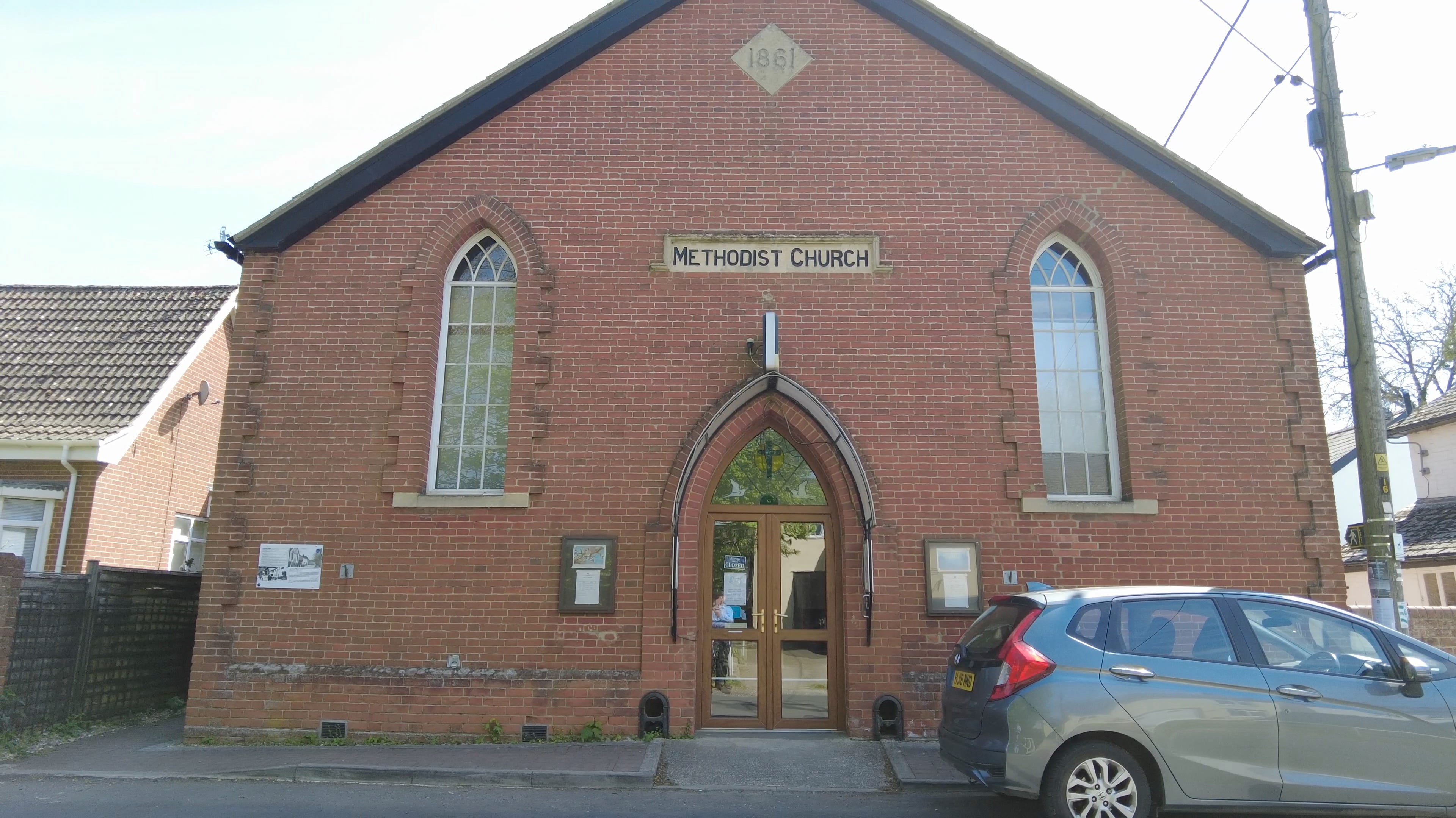
Opposite is a Methodist Church which appears to be well used in the community. It was built in 1861 on land with a ninety-nine year lease. The lease was five shillings per year or a copy of the Holy Scriptures. A very modest amount!
I am almost in sight of the end of the route and a drink is needed. I call into the local Co-op to buy a cold drink. All the staff are shelf-filling and so I use the self-checkout. Why does it always take longer to use these things than being served by a human? Firstly, the darn thing added a bag - then it needs editing to take it off the total price, then press another button etc etc… My words of wisdom to the people that design technology solutions — Just because you can, doesn’t mean you should!
With the benefit of few swigs of Dr Pepper I am now back at the starting point of my ‘Shrewton Trail’ and getting rehydrated after quite a walk. It was good to finally take this walk and it’s certainly enjoyable. There is such a wonderful mixture of buildings, countryside and nature along the route coupled with some history.

Thank you for reading. I hope you have enjoyed my review of this walk, and please, do become a subscriber for more stories.